


From the launch of the first AR mobile app in 2008 by Wikitude to gaining massive popularity with the location-based AR game Pokemon GO, Augmented Reality has been put on the mainstream map of mobile app development. Till then, AR market size, share, & industry growth have been skyrocketing, projecting a compound annual growth rate of 31.5% between 2023 and 2026.
The AR market growth is fueled by its transformative applications across various sectors. One such area where this technology is getting recognized is the augmented reality navigation app development, which provides a highly intuitive and immersive way to navigate and find directions.
Embedding digital elements directly into the real world, augmented reality navigation makes it easy for users to understand where to go through their smartphone device’s camera lens. This significantly enhances situational awareness with real-time updates on traffic, any obstacles, and even points of interest.
What is an Augmented Reality Navigation App?
An Augmented Reality Navigation App overlays real-time, interactive direction guidance onto the physical world. These apps use a combination of camera input, GPS, sensors, and AI-driven algorithms to enhance navigation, providing accurate and responsive navigation.
Unlike traditional navigation apps that rely on 2D maps, AR navigation apps project virtual paths, arrows, and location markers directly onto the user’s real-world view.
How Does an Augmented Reality Navigation App Work?
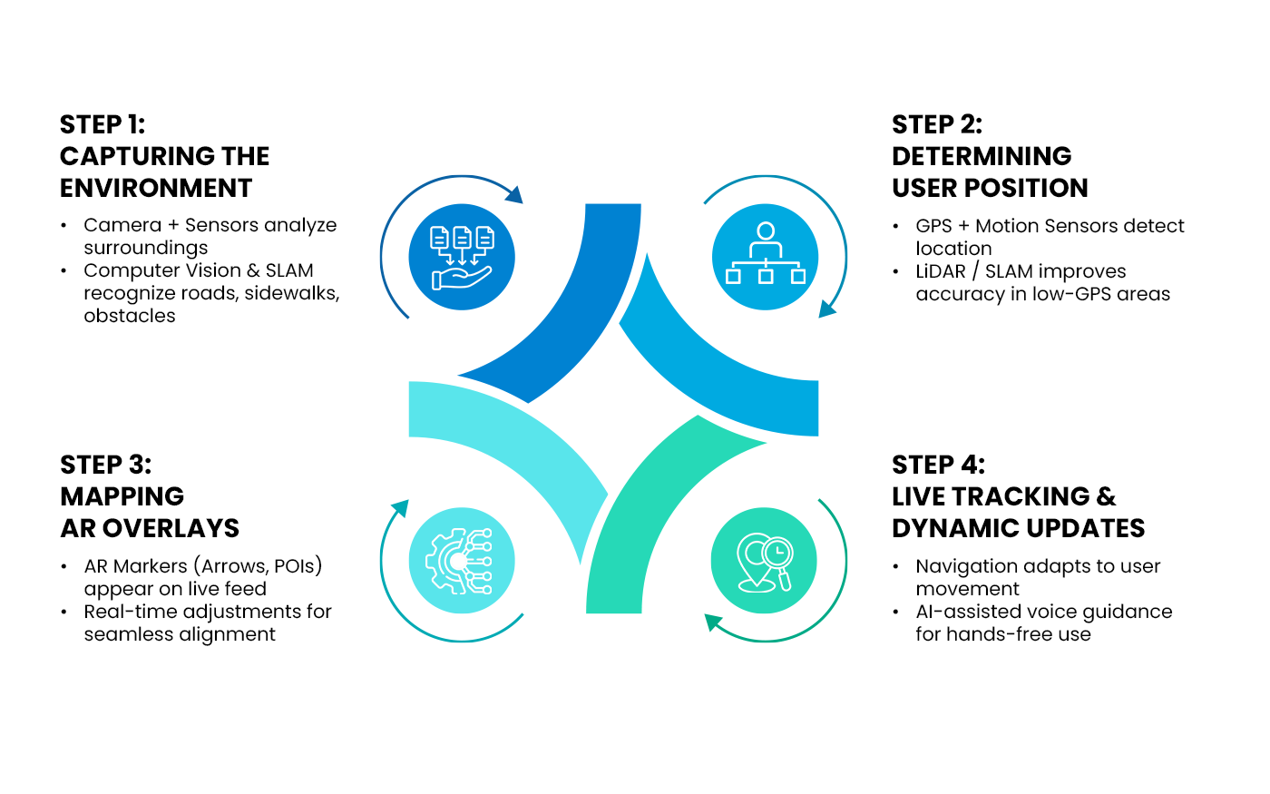
To create effective augmented reality navigation systems, multiple technologies work together:
Computer Vision
With computer vision, augmented reality navigation apps recognize and understand the real-world environment using the camera of the device. Detecting roads, pathways, buildings, and landmarks, CV aligns virtual navigation elements with real-world structures.
Simultaneous Localization and Mapping
SLAM is a core technology used for outdoor and indoor navigation systems using augmented reality. This helps in continuously mapping the environment while real time tracking the user’s position.
GPS & Geolocation Services
GPS provides location data by triangulating signals from satellites, which is an important factor for AR to overlay digital elements in the correct location. Combined with Wi-Fi positioning and cellular triangulation, GPS is often used for improved accuracy in urban areas.
Light Detection and Ranging
This technology enhances depth perception by measuring distances between objects using laser pulses. Commonly found in high-end smartphones and devices, it improves augmented reality navigation in low-light conditions.
An augmented reality directions app using this technology can create an intuitive and immersive experience to explore the world.
The Impact of AR Navigation Across Industries
Augmented Reality navigation apps are transforming how industries optimize engagement and accessibility, with real-time, interactive guidance customized to specific industry needs.
Tourism & Travel
Tourists can explore cities with AR-guided city tours highlighting landmarks and sites. It can also translate street signs, menus, and directions with language translation in real-time, which makes travel easier.
Education & Training
There are many uses of augmented reality navigation apps in universities, like helping students and visitors find classrooms, libraries, and facilities. Integrated with learning tools, it can enhance STEM education by visualizing complex concepts in real-world settings.
Healthcare
Patients and staff can use hospital augmented reality maps to quickly locate departments, wards, and emergency exits. Also, it can assist in medical training & simulation by improving precision and patient care in surgeries and diagnostics.
Retail & eCommerce
With augmented reality walking directions and in-store navigation, customers can easily find products inside supermarkets and malls. Brands are also offering AR product visualization inside their homes to enhance the online shopping experience.
Museums & Exhibitions
Indoor navigation with augmented reality makes it easy to guide visitors through galleries while providing immersive storytelling experiences in Museums and Exhibits.
Smart Cities & Public Transport
Augmented Reality navigation apps help commuters find the nearest transit stops and ticket counters for metro and bus-a great addition to pedestrian—friendly smart city development.
Military & Defense
Military forces use augmented reality navigation for better situational awareness, planning missions, identifying threats, and mapping terrain in complex environments.
Real-life Use Cases & Solutions in AR Navigation
Whether it is indoor navigation with augmented reality in malls, airports, or smart cities, this technology is highly crucial in making navigation more interactive and accurate.
Below are key real-world applications of augmented reality navigation systems across different environments.
Augmented Reality Indoor Navigation
It can be challenging for people to navigate through indoor spaces like malls, airports, and hospitals. Augmented reality indoor navigation simplifies this by embedding digital directions onto a real-world view.
Using a combination of technologies like beacons, LiDAR, and SLAM for an indoor navigation system using augmented reality enable users to find their destination with ease.
Augmented Reality GPS Navigation Systems
For outdoor navigation, augmented reality GPS navigation systems provide enhanced route guidance. This eliminates the limitation of traditional maps that require constant glances at a phone screen.
Popular applications like Google Maps Live View utilize ARCore and geospatial data to project arrows and landmarks directly onto streets.
Augmented Reality Walking Directions
Exploring a new city or navigating a university campus is easier with augmented reality walking directions since it provides real-time turn-by-turn instructions, highlighting key points of interest. These applications use CV and location-based AR to analyze the surroundings and adapt navigation overlays as the user moves.
AR City by Blippar is a great example of an augmented reality map app that recognizes buildings and streets, guiding users with interactive visual cues.
Augmented Reality Map Applications
AR-based mapping technology is revolutionizing how users interact with navigation tools. Augmented reality map applications transcend traditional static maps through 3D models, interactive markers, and contextual information. This approach is beneficial in smart cities, tourism, and public transportation.
Compared to conventional mapping solutions, augmented reality maps offer a more immersive and user-friendly experience through an AR-enhanced view, such as:
- Real-time transit schedules
- Restaurant reviews
- Historical site details
Augmented Reality Car Navigation
In the automotive industry, augmented reality navigation systems are being used to improve safe driving. Many modern vehicles, feature AR-powered Head-Up Displays that project navigation cues onto the windshield, allowing drivers to follow real-time lane guidance, and turn instructions directly in their line of sight.
Top Augmented Reality Navigation Apps in the Market
Walking in a new city using an augmented reality map app to driving with BMW augmented reality navigation, these apps are great for improved accuracy and safety. Here are some of the top augmented reality navigation apps categorized by consumer navigation and automotive systems.
Consumer AR Navigation Apps
-
Google Maps Live View
One of the most widely used augmented reality navigation apps, Google Maps Live View, overlays augmented reality walking directions onto real-world environments. Using ARCore and geospatial data, it provides real-time arrows, street names, and points of interest for more intuitive navigation.
-
Wikitude World Browser
Wikitude is contributing to the AR navigation space through products, services, to even technologies. This augmented reality map app enhances city exploration through the display of digital content over real-world landmarks, helping users discover information simply by pointing their phone camera.
-
AR City by Blippar
A feature-rich augmented reality map that recognizes streets and buildings, offering augmented reality directions for pedestrians. It leverages computer vision and GPS to create an interactive city navigation experience.
-
Sygic GPS Navigation & Maps
This augmented reality navigation app integrates turn-by-turn directions, making it easier for drivers and walkers to navigate unfamiliar routes. The app projects a virtual path onto the camera feed, providing a real-time updates for enhanced visibility.
-
Waymap
Designed for accessibility, Waymap is an augmented reality navigation system for visually impaired users. The app provides highly accurate augmented reality walking directions without requiring GPS, ideal for indoor and outdoor navigation.
-
AR GPS Drive/Walk Navigation
This augmented reality navigation app uses live AR overlays to guide users on foot or while driving. It helps in city navigation by integrating real-time arrows, distance markers, and speed indicators onto a mobile screen.
Automotive AR Navigation Systems
-
Audi Augmented Reality Navigation
Found in premium Audi models, this augmented reality car navigation system projects AR-enhanced directions onto the vehicle’s windshield. It provides real-time lane guidance, turn-by-turn AR navigation, and hazard alerts, reducing driver distraction.
-
BMW Augmented Reality Navigation
The BMW augmented reality navigation system integrates with the car’s infotainment display, overlaying real-time AR navigation onto the road ahead. It highlights street names, lane recommendations, and dynamic waypoints for better driving assistance.
-
Mercedes MBUX AR Navigation
A state-of-the-art augmented reality navigation system, the MBUX AR system overlays dynamic road information, signals, and house numbers onto the vehicle’s screen, improving route visibility. It is particularly useful in urban environments where traditional GPS instructions may be unclear.
How to Build an Augmented Reality Navigation App?
Building an augmented reality navigation app requires expertise in AR development, geolocation, and UI/UX design. By leveraging the right technologies and best practices, you can create an immersive and reliable augmented reality GPS navigation system that enhances real-world navigation for users.
-
Project Scope & Data Requirements
Before development begins, outline the key functionalities your augmented reality navigation app needs.
Consider:
| User needs | Indoor vs. outdoor navigation, turn-by-turn guidance, accessibility features. |
| Data Sources | High-precision geospatial data, real-time traffic updates, and indoor positioning systems. |
| Platform compatibility | iOS, Android, or both |
-
Choosing the Right Tech Stack
A robust AR navigation system relies on multiple technologies for accurate tracking, rendering, and interaction.
-
AR SDKs
| ARCore Geospatial API (by Google) | Enables real-world augmented reality directions using GPS and visual positioning. |
| ARKit (by Apple) | Provides augmented reality map app development tools with LiDAR support. |
| Wikitude | Supports indoor navigation with augmented reality and marker-based tracking. |
Mapping & Geolocation APIs
| Google Maps API | For augmented reality GPS navigation system with real-time data. |
| OpenStreetMap / Mapbox | Open-source alternatives for custom augmented reality maps. |
3D Rendering Engines
| Unity 3D | Popular for AR applications with real-time 3D overlay support. |
| Unreal Engine | Offers high-quality AR rendering for a more immersive experience. |
UI/UX Best Practices for AR Navigation
| Keep overlays clear and unobtrusive | Avoid cluttering the screen with excessive markers or text. |
| Ensure smooth interactions | AR elements should align perfectly with real-world roads, landmarks, and turns. |
| Reduce motion sickness | Stabilize AR overlays and minimize excessive motion in the AR view. |
Implementing Real-time Geolocation & Object Recognition
| GPS & SLAM | Essential for indoor navigation systems using augmented reality, especially when GPS signals are weak. |
| LiDAR & AI-powered Object Recognition | Improves real-time positioning accuracy and enhances augmented reality navigation systems for better interaction with surroundings. |
Testing & Optimizing the App for Performance
| Real-world accuracy testing | Validate navigation in various environments (urban, indoor, low-light). |
| Performance optimization | Reduce battery drain, optimize rendering speed, and ensure smooth real-time updates. |
| User feedback & iteration | Continuously refine the app based on real-world user testing. |
Challenges in AR Navigation App Development & Solutions
An augmented reality navigation app development comes with technical and practical challenges. Such challenges can impact accuracy, performance, and also user experience.
Here, let us discuss those obstacles and the methods to overcome them.
-
GPS Inaccuracy & AR Misalignment
Having relied on GPS, accelerometers, and gyroscopes, augmented reality navigation apps have the ability to determine location. However, urban environments, tunnels, and indoor spaces can lead to inaccurate positioning and misaligned AR overlays.
Solution:
- Implement SLAM to enhance indoor navigation with augmented reality without relying on GPS.
- Use LiDAR and computer vision to improve real-world object recognition and overlay accuracy.
- Combine GPS with Wi-Fi, Bluetooth beacons, and 5G networks for better positioning in complex environments.
-
Virtual Object Stability & Rendering Issues
AR elements such as arrows and markers can flicker, drift, or fail to stay in place due to poor rendering and environmental inconsistencies.
Solution:
- Use AI-driven object recognition to dynamically adjust surface based on real-world conditions.
- Implement cloud-based AR processing for high-precision rendering.
- Optimize frame rates and 3D rendering using ARCore Geospatial API, ARKit, or Wikitude to ensure seamless AR object placement.
-
Battery Drain & Performance Optimization
AR navigation apps require real-time data processing, 3D rendering, and constant location tracking, leading to high battery consumption and performance bottlenecks on mobile devices.
Solution:
- Optimize AR rendering with edge computing and cloud-based processing to reduce device load.
- Implement adaptive refresh rates that lower AR rendering frequency when the user is stationary.
- Use energy-efficient SDKs that minimize processing demands without compromising AR quality.
-
User Privacy & Data Security Concerns
AR navigation apps collect sensitive data, which raises privacy concerns and regulatory challenges.
Solution:
- Ensure GDPR and CCPA compliance for end-to-end encryption and transparent user data policies.
- Minimize data collection by processing navigation data locally on devices rather than storing it on external servers.
- Provide users with control over location sharing and anonymous usage options to enhance trust and security.
By addressing these core challenges in augmented reality navigation app development, businesses can build highly accurate, secure, and user-friendly systems that enhance wayfinding experiences across industries.
Cost of Developing an Augmented Reality Navigation App
Developing an augmented reality navigation system involves various cost factors, such as:
- Feature complexity
- Platform choice
- Integration capability
The budget varies depending on whether you’re creating a basic AR navigation system or an advanced augmented reality GPS navigation system with AI-powered enhancements.
Cost Breakdown by Feature Complexity
| Feature | Basic App ($30,000–$60,000) | Mid-Level App ($60,000–$100,000) | Advanced App ($100,000–$300,000+) |
| AR Navigation (Basic Overlays) | ✅ | ✅ | ✅ |
| Turn-by-Turn AR Directions | ❌ | ✅ | ✅ |
| Real-Time Object Recognition | ❌ | ✅ | ✅ |
| LiDAR & SLAM Support | ❌ | ✅ | ✅ |
| 3D Augmented Reality Map | ❌ | ✅ | ✅ (HD maps, real-world scaling) |
| Voice-Guided AR Navigation | ❌ | ❌ | ✅ |
Estimated Cost Ranges Based on Features
| App Complexity | Cost Range | Features |
| Basic AR Navigation App | $30,000–$60,000 |
|
| Mid-Level AR Navigation App | $60,000–$100,000 |
|
| Advanced AR Navigation App | $100,000–$300,000+ |
|
Key Cost Factors Affecting AR Navigation App Development
| Platform Choice | Android, iOS, or cross-platform apps impact development time and cost. |
| AR SDK & Mapping APIs | Costs vary based on tools like ARCore, ARKit, Wikitude, Google Maps API, Mapbox. |
| 3D Modeling & UI/UX Design | Creating high-quality AR overlays and interactive elements increases costs. |
| AI & Machine Learning | Advanced features like object detection and adaptive navigation add complexity. |
| Testing & Optimization | AR navigation apps require extensive testing in varied environments (indoor, urban, low-light). |
For businesses investing in augmented reality navigation systems, the mobile app development cost depends on the level of precision, interactivity, and AI-driven automation required.
Why Choose Successive Digital to Build Your AR Navigation System?
Developing a robust augmented reality navigation system requires expertise in AR technologies, real-time geolocation, and seamless user experiences. At Successive Digital, we specialize in building high-performance AR navigation apps that transform the way users interact with their surroundings.
Proven Expertise in Augmented Reality Navigation App Development
With years of experience in building augmented reality navigation systems, we have successfully delivered solutions across various industries. Our team has years of experience in using intelligent, AI-driven navigation technologies to build immersive and precise AR navigation solutions.
| Customized AR Experiences
We design a custom augmented reality map app that aligns with business goals, whether for outdoor or indoor navigation with augmented reality. |
Cross-Platform Compatibility
We develop AR navigation apps that work effortlessly across iOS, Android, and automotive HUD systems. |
| AI-Enhanced Navigation
Our solutions incorporate real-time object recognition, AI-powered routing, and adaptive overlays for seamless user guidance. |
Optimized for Speed & Accuracy
Our augmented reality navigation solutions use high-resolution AR mapping and precise turn-by-turn directions for smooth navigation. |
At Successive Digital, we build augmented reality navigation systems that redefine wayfinding and user experience. With advanced technology integration and innovation, let’s bring your AR navigation vision to life!